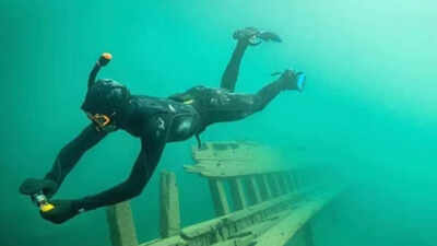
A place where different periods of history coalesce, might perhaps be under water, where time is still unmoving. Lake Superior, in North America, beneath its blue depths, has surprised researchers with findings that date back to the mining industry of the 1880s, but also to the evidence from a railway derailment in 2008.According to a report by TimminsToday, underwater archaeologists from Parks Canada explored several historical sites in Lake Superior during the summer, including the remains of an old silver mine and two railway cars that had plunged into the lake following a train derailment in 2008. The investigations have been a part of the agency’s continuing effort to document archaeological resources underwater in the Lake Superior National Marine Conservation Area. What makes the exploration particularly interesting is that researchers were not only looking at shipwrecks, but also at industrial structures and objects that tell us about the ways people once worked and travelled around the region.
Exploring the remains of a historic silver mine
One of the sites examined by the underwater archaeology team was the Silver Islet mine, an offshore silver mining operation that functioned during the 1870s and continued into the mid-1880s. Located beneath the waters of Lake Superior, the mine was once considered the world’s richest silver mine, but what made it even more unusual was that it wa an offshore mine.Mining beneath a lake was no ordinary undertaking. The operatiosn depended on protective structures and pumps which prevent water from entering the shafts. Breakwaters were constructed around the site to protect it from the lake, while pumps had to operate continuously to keep the underground workings from flooding.According to Ontario Parks, in an article dated January 25, 2022, the Silver Islet mine shaft is hundreds of metres deep into the lake. During the recent investigation, the underwater archaeologists had focused on documenting what remained of the original breakwater and the mine shafts. However, exploring the interior was not straightforward. There was considerable debris obstructing the way, which prevented divers from travelling very far inside the mine. Instead, the team used a remotely operated submersible vehicle to investigate the deeper sections, reaching nearly 40 metres below the surface.The vehicle helped researchers document the shaft structures and ladders that connected on different levels of the mine. Rather than simply recording the location of an abandoned mine, the team was able to examine surviving structures that reveal something about the way workers once moved through the site.Although the Silver Islet mine is not technically within the boundaries of the Lake Superior National Marine Conservation Area, it remains privately owned, the team received permission to study it. Its historical significance made it an important site to document, particularly because it forms part of the local history of the region.
Two railway cars that remained underwater since 2008
The investigation also took the archaeologists to another location along Lake Superior’s North Shore, near Rossport. This time, the focus was not a mining operation but two railway cars that had plunged into the lake during a train derailment in 2008. The cars were never recovered and had remained underwater since the incident.According to TimminsToday, Parks Canada’s underwater archaeology team had received information about the submerged railway cars from people who had repeatedly brought the incident to their attention. This led the researchers to then examine the location and try to identify the rail cars. The investigation team was interested in more than simply confirming the railway cars were still there, they also hoped to understand what they had been carrying when they entered the water. So, finally, their examination suggested that one car contained some type of paper, allowing them to determine the specificities of what they had discovered.
Documenting what lies beneath Lake Superior
The work was carried out by Parks Canada’s 12-member underwater archaeology unit, which consists of diving specialists who examined the submerged landscapes, such as shipwrecks and other archaeological sites. The team also works to gather information that can help Parks Canada develop future interpretation programmes and make these sites better understood by the public.The Lake Superior National Marine Conservation Area itself covers more than 10,000 square kilometres, extending across a substantial portion of the Canadian side of the lake. It includes waters stretching from the Sibley Peninsula towards the Slate Islands and the marine border between Canada and the United States. With such a vast area to investigate, documenting every underwater site is a considerable undertaking.As Charles Dagneau, acting manager of Parks Canada’s underwater archaeology team, explained to TimminsToday, the work is also dependent on the lake and its weather conditions. Even when researchers know where to look, reaching and documenting a particular site is not always possible. The natural world, or rather in this case, the lake can be a vessel, a repository of human history, where the same site can preserve remains of a 19th century mining operation and also hold traces of an unprecedented accident from the 21st century.